The condition of urban infrastructures
Infrastructures are the backbone of any society as they play a key role in providing the essential systems needed for daily life. Regular inspection and maintenance of these infrastructures are of utmost importance to extend their lifespan as well as ensure public safety. If we consider the US, most infrastructures were built in the 20th century, mainly as a result of massive infrastructure investments by the US federal government in the late 1930s. These infrastructures are rapidly ageing and deteriorating due to material ageing, excessive use, climatic conditions and insufficient maintenance. The American Society of Civil Engineers (ASCE) grades the state of the nation’s infrastructures on a scale of A to F every four years. The most recent grading done on 2021, gave the country’s infrastructure an average grade of ‘C-’ across all categories [1]. The problem is particularly severe in urban areas, where rapid population increase stresses existing infrastructures.
Monitoring infrastructures with radar
Monitoring of infrastructures on a regular basis is important for ensuring its smooth operation. However, manual monitoring methods such as a trained professional physically inspecting the infrastructure is time consuming, tedious and inefficient. Non-Destructive Testing (NDT) of infrastructures is a method of evaluating the health of an infrastructure without affecting its operation or causing any physical damage to it. Combining two radar based monitoring technologies – Synthetic Aperture Radar (SAR) and Ground Penetrating Radar (GPR) could be an effective NDT solution for infrastructure monitoring.
SAR satellites can be used for monitoring millimeter level surface deformations for large areas using a technique called Interferometric SAR (InSAR). GPRs on the other hand, can be used for performing high resolution scans of the subsurface, revealing different geophysical properties. Within this context, we can integrate the wide area coverage capacity of InSAR with the detailed subsurface imaging capacity of GPR to provide a comprehensive infrastructure monitoring solution.
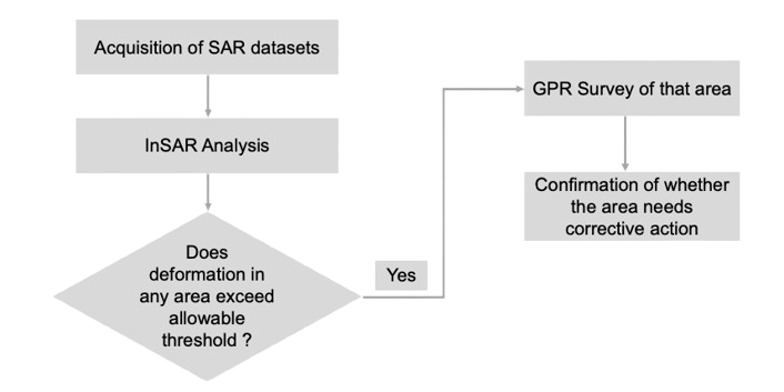
The first step would be to perform an InSAR analysis over a large area to detect places with anomalous deformation. A detailed GPR analysis can then be performed over these areas to further investigate the overlying cause for the anomalous deformation and to decide on the corrective action required. The flowchart below summarizes the methodology:

Case study
The combination of geophysical methods like InSAR and GPR has already shown some promising results in infrastructure monitoring. This can be demonstrated by the case study involving the monitoring of 26 km of an operational railway track in the Puglia region of Southern Italy [2].
For this study, 44 SAR images from the Sentinel-1 satellite and 56 images from Cosmo-SkyMed satellites, spanning a time period from April 2017 to January 2018 were acquired. Interferometric analysis and post processing of the interferograms was performed on these images to obtain time series subsidence maps of the area as shown in figure 2(a). In this figure, we can see that a 500-meter section of the railway track shows high subsidence values (red dots), which can be seen more clearly in the zoomed-in version in figure 2(b).

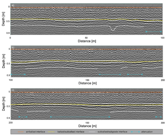
A detailed GPR analysis of the detected subsidence area was also conducted to investigate a correlation between the high subsidence result from InSAR and GPR measurements. Figure 3 shows the results of GPR measurements done over a 300 m stretch of the railway.

GPR analysis of the area identified several spots with high attenuation of the radar signal. This is most likely attributed to the uprising of highly conductive fine particles from the subsurface. This hypothesis aligns well with the geological analysis of the area which reported clayey subsurface layers for the first 1.5 km of the area. Furthermore, the assumption is also supported by analysis of videos of the investigation area, which highlighted the presence of clayey materials at the edge of the railway tracks.
The combination of InSAR and GPR thus offer valuable insights into the mechanisms behind the subsidence in the area. This case study demonstrates how the strengths of different applied geophysical methods can be combined to achieve a more holistic infrastructure monitoring solution.
Conclusion
The combination of InSAR and GPR offers a promising solution to the challenge of urban infrastructure monitoring. Initial pilot project on a few selected infrastructure sections can demonstrate project feasibility before scaling it up to cover a bigger area. Although the low resolution in currently available InSAR capable SAR satellites makes it difficult to apply this technology for monitoring buildings, the technology in it’s current state can be applied for monitoring infrastructures such as railways, highways and bridges. With advancements in commercial SAR satellite technology from the new space industry, this technology has a huge potential to be applied to monitor all kinds of infrastructures in the near future.
References
- American Society of Civil Engineers. (2024). 2024 Bridging the Gap Economic Study. Retrieved from https://bridgingthegap.infrastructurereportcard.org/wp-content/uploads/2024/05/2024-Bridging-the-Gap-Economic-Study.pdf.
- Bianchini Ciampoli, L., Gagliardi, V., Clementini, C., Latini, D., Del Frate, F., & Benedetto, A. (2020). Transport Infrastructure Monitoring by InSAR and GPR Data Fusion. Surveys in Geophysics, 41(3), 371–394. https://doi.org/10.1007/s10712-019-09563-7.
